A play of colors and a game of aromas in a surprising volcanic setting.The lake is impressive in many ways as are its boundaries; a dam was constructed in 1921 to prevent a breakout flood with catastrophic overflows. This sulphuric lake is the most acidic in the world, so are its rivers.
Pre- and post-caldera activity of Ijen
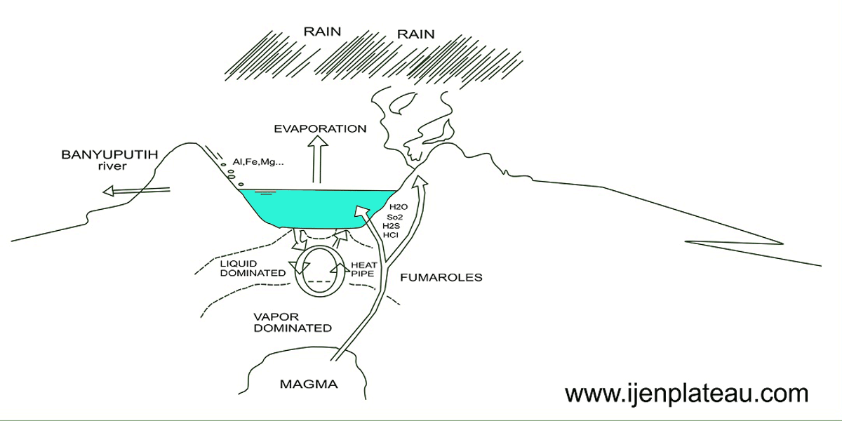
How Ijen crater lake works; how it contains its water - East Java.Pre-caldera activity of the Ijen crater complex is supposed to have started prior to 300,000 years ago. It probably formed a large single stratovolcano - Old Ijen - with an estimated altitude of 3500 m. The caldera formation is associated with the eruption of a large volume – around 80 cubic kilometers - of pyroclastic flow deposits. These are waves that consist of solid or semi-liquid lava, gas, rocks and ash. They can reach temperatures up to about 850°C and can reach a speed to around 725 km/h. The event occurred some time before 50,000 years ago. This is based on analysis of a lava flow of Mt. Blau. Mt. Blau is considered to be the oldest post-caldera unit.
Post caldera activity produced the rim cones and the inner cones. These younger volcanoes produced the ash and scoria cones, lava flows, pyroclastic flow and surge deposits and debris avalanche material that now cover the caldera flow.
Ijen's landscape full of volcanic cones
The Ijen Plateau was at one time a huge active crater complex of 134 square kilometers in area. Nowadays, the large caldera complex hosts a large number of volcanic structures of which Ijen and Raung are the most active. The Ijen caldera has a diameter of about 14-16 km.
The landscape is dominated by the volcanic cones of Ijen (2368 m) and Merapi (2800 m) on the north-eastern edge of the plateau, and Raung (3332 m) on the south-western corner. The Ijen crater stands inside the caldera, while Merapi and Raung have arisen along a ring fracture at the edge of the caldera. The caldera’s northern margin is clearly visible as a typical caldera escarpment with a steep inner slope and elevations ranging from 850 to 1559 m.
The southern and eastern walls are covered by the marginal volcanoes of Suket (2950 m), Jampit/Pendil (2338 m), Rante (2644 m), Merapi (2799 m), Ijen (2386 m), Pawenen (2123 m) and Ringgih (1965 m). Inside the caldera the topography is dominated by a large number of extinct volcanic cones: Cilik (1872 m), Pendil (2375 m), Anyar (1276 ), Genteng (1712 m), Gelaman (1726 m), Kukusan (1994 m), Papak (2099 m), Idodaren (2100 m), Blau (1774 m), Gendingwaluh (1519 m), Lingker (1630 m) and Kunci (1788 m).
 Eruptions over time
Ijen is especially interesting because of a relationship seen between lake level and eruptive activity. On several occasions when the lake level has been lowered by artificial means, fumarolic activity under the lake has increased, lake temperature has risen, and sometimes hydro-thermal or phreatic eruptions have occurred. These phenomena are thought to result from reduced pressure resulting from lowering the lake level.
The historical record of volcanic activity at Ijen dates back to 1586, and includes dozens of eruptions. Eruptions of Ijen are associated with increases in seismic activity and in the temperature of the crater lake. In 1817 the crater lake in Kawah Ijen collapsed, producing mud-flows that engulfed three villages and killed an unknown number of people. In 1917 water from the lake flowed over after a large tectonic earthquake near Bali. The following month water in the lake was spouting some 9 m into the air in a muddy, noisy display. The temperature of the lake rose to scalding intensities in March but dropped back to lukewarm levels by late 1917. The lake heated up again in 1921, with steaming gases above the water surface until 1923.
In 1936 an eruption similar to that of 1817 was recorded. In 1952 Ijen erupted after several strong local earthquakes. The volcano spewed ash up to 1000 meters altitude in the air. An eruption cloud appeared, and boiling activity was observed in the lake. In 1962, 1976 and 1991 bubbling water was recorded, with changing of water colour. In 1993 an explosive volcanic eruption was recorded in which steam and tephra was released. In 1997 there was increased seismic activity recorded. The colour of the lake changed, gas bubbles were seen and there was a strong sulphuric odor; birds were seen falling into the water. The last eruption was recorded in 1999.
Table 1. Erutive activity (source: M.J. van Bergen, et al., 2000. Crater lakes of Java: Dieng, Kelud and Ijen. IAVCEI General Assembly, Bali)
Year Description
1796 Phreatic eruption
1817 Phreatic eruption15-16 January: phreatic eruption, flooding of mud towards Banyuwangi, and a fairly large volume of lake water was discharged into the Banyupahit River
1917 25 February-14 March: lake seemed to boil; repeated phreatic eruptions, mud thrown up to 8-10 m above the lake surface
1921-1923 Increasing lake water temperature; steaming gases above water surface
1936 5-25 November: phreatic eruption producing lahar similar to that of 1796 and 1817
1952 22 April: steam eruption up to 1 km high; mud thrown up to 7 m above the lake
surface
1962 13 April: 7 m high eruption; gas bubbles on lake surface, about 10 m in diameter
18 April: bubbling water up to 10 m high, changing of watercolor
1976 30 October: bubbling water at Silenong for 30 minutes
1991 15,21,22 March: bubbling water and changing of water color, 25-50 m high gas outpouring at high velocity; this activity was recorded as seismic tremor between 16 and 28 March
1993 3,4,7 July and 1 August: phreatic eruptions, changing of lake water color, water outpouring, booming noise, clotted steam; all centered in the middle of the lake
1994 3 February: minor phreatic eruption from the south part of the lake. Coincident with the eruption, the lake level rose ~1 m
1997 Late June: period of increased seismic activity; changing of lake water color; gas bubbles and areas of up welling; strong sulphuric odor; birds were seen falling into the water; one or more sulphur workers near the summit reported dizziness and headaches
1999 28 June: two phreatic eruptions at the Seating location. An accompanying detonation was heard at the sulphur-mining site 2 km from the summit and volcanic tremor was recorded with an amplitude of 0.5-1 mm. The following week, 6-12 July, yellow-grey sulphur emissions were observed from the crater and a loud "whizz" noise was heard. The crater lake’s water was brownish-white and had sulfur agglutinate floating on the surface. Seismicity had increased starting in early April. The number of B-type events remained high (more than 34/week) for most of the period through mid-June. Seismicity then gradually declined through mid-July, after which the weekly number of B-type events remained stable at an average of 9/week. During the period of 18 May through the week ending on 21 June a "white ash plume" rose 50-100 m.